Follow us
facebook
instagram
x
youtube
tiktok
pinterest
threads
Latest News
Second British F-35B Fighter Jet Makes Emergency Landing in Japan
August 11, 2025
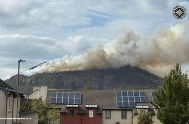
Fire Erupts on Edinburgh’s Arthur’s Seat, Crews Battle Blaze Visible Across the City
August 11, 2025
Man Killed After Tractor Collides with Parked Vehicles at Gloucestershire Vintage Show
August 11, 2025
Transparent. Unbiased. Yours.
Toggle sidebar & navigation
Home
Breaking News
Economics
Politics & Government
Crime
General News
More
Human Rights
Defence & Security
Crypto
Finance
Real Estate
Home
Breaking News
Economics
Politics & Government
Crime
General News
More
Human Rights
Defence & Security
Crypto
Finance
Real Estate
Breaking News
Second British F-35B Fighter Jet Makes Emergency Landing in Japan
August 11, 2025
Fire Erupts on Edinburgh’s Arthur’s Seat, Crews Battle Blaze Visible Across the City
August 11, 2025
Man Killed After Tractor Collides with Parked Vehicles at Gloucestershire Vintage Show
August 11, 2025
Proposed Road Safety Reforms Could Bring Mandatory Eye Tests for Older Drivers and Stricter Drink-Drive Limits
August 11, 2025
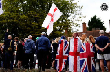
Community Anger Grows Over Use of Hotels to House Asylum Seekers
August 10, 2025
Chagos Islands Transfer Projected to Cost Nearly £35 Billion, Official Figures Show
August 10, 2025
Major Blaze Erupts on Edinburgh’s Iconic Arthur’s Seat
August 10, 2025
NHS Patients Face Lengthy Treatment Waits Across the UK
August 10, 2025
Zelenskyy Rejects Trump’s Ukraine Land Swap Proposal
August 10, 2025
Man Harasses Teen on Manchester Bus, Confronted by Mother
August 10, 2025